01
Global Mapping System
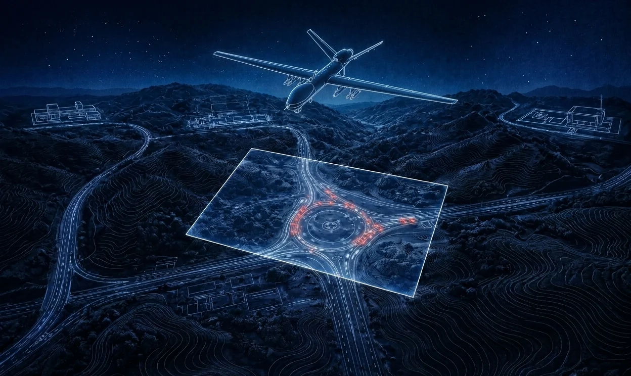
Elite Mapper
Petabyte-scale geospatial visualization. Raster, vector, and elevation rendered live in 3D · cloud-native, battle-proven, government-deployed.
View Details ↗
Visor Dynamics · Est. Deep Tech R&D
For the Future
With over a decade of experience in creating petabyte scale geospatial systems that provide immeasurable value to both private and government organizations, Visor Dynamics has built its reputation as one of the very few companies in the region working on deep tech R&D and setting up its own standards and formats.
Platforms spanning geospatial intelligence, electronic warfare, AI reasoning, precision agriculture, and airborne systems. Built for those who operate at the edge of what is possible.
Petabyte-scale geospatial visualization. Raster, vector, and elevation rendered live in 3D · cloud-native, battle-proven, government-deployed.
View Details ↗Centimeter-scale terrain, globally. Proprietary compression delivers high-resolution elevation to low-bandwidth edge systems · on the fly.
View Details ↗National-scale agricultural intelligence. A cloud-native data bank for storage, visualization, and AI analysis of an entire nation's agricultural landscape. Awarded by NASTP, deployed nationally.
View Details ↗Our most advanced AI system for mission planning, threat assessment, forecasting warfare, and more.
Learn More ↗Receive, profile, and act on radar and RF signals in real-time. Multi-layer AI analysis across pulse, hop, and IQ data. Deployable airborne, ground, or maritime.
View Details ↗Fuse Electronic Order of Battle, DF, and jammer data from a distributed sensor array into a single operational picture.
View Details ↗See the invisible. Our airborne ESM console processes direction-finding streams in real-time, surfacing threat locations with precision that keeps operators one step ahead.
Processes data from static and dynamic DF arrays. Deployable on fixed-wing, rotary, and UAV platforms.
Our very own reduced-hallucination architecture. Enhances clarity, reduces atmospheric distortion and compression artifacts · without inventing detail.
Talented individuals from geospatial, AI, deep tech R&D, and defense strategy. A rare blend that creates immeasurable value where it matters most.

Ali Ashraf
Chief Executive Officer

Muhammad Shoaib
Tech Lead

Faeez Shabbir
Generalist Developer

Ameer Hamza
Integration Engineer

Khizar Waseem
Modernization Engineer

Masna Bin Umeed
Head of Product Design

Mahrukh Agha
Lead Geospatial Analyst
We are rapidly expanding and seeking individuals with relentless curiosity and a dedication to advancing deep tech. If that sounds like you, we want to hear from you.
We would love to hear from you. Send us a LinkedIn message for information about our products, services, and solutions.