GPS Denial and Visual Positioning Systems
GPS denial is now routine, and militaries have worked on visual positioning systems for decades. So why isn't visual positioning on every military drone? Most of the problem is the map, the data and the compute.
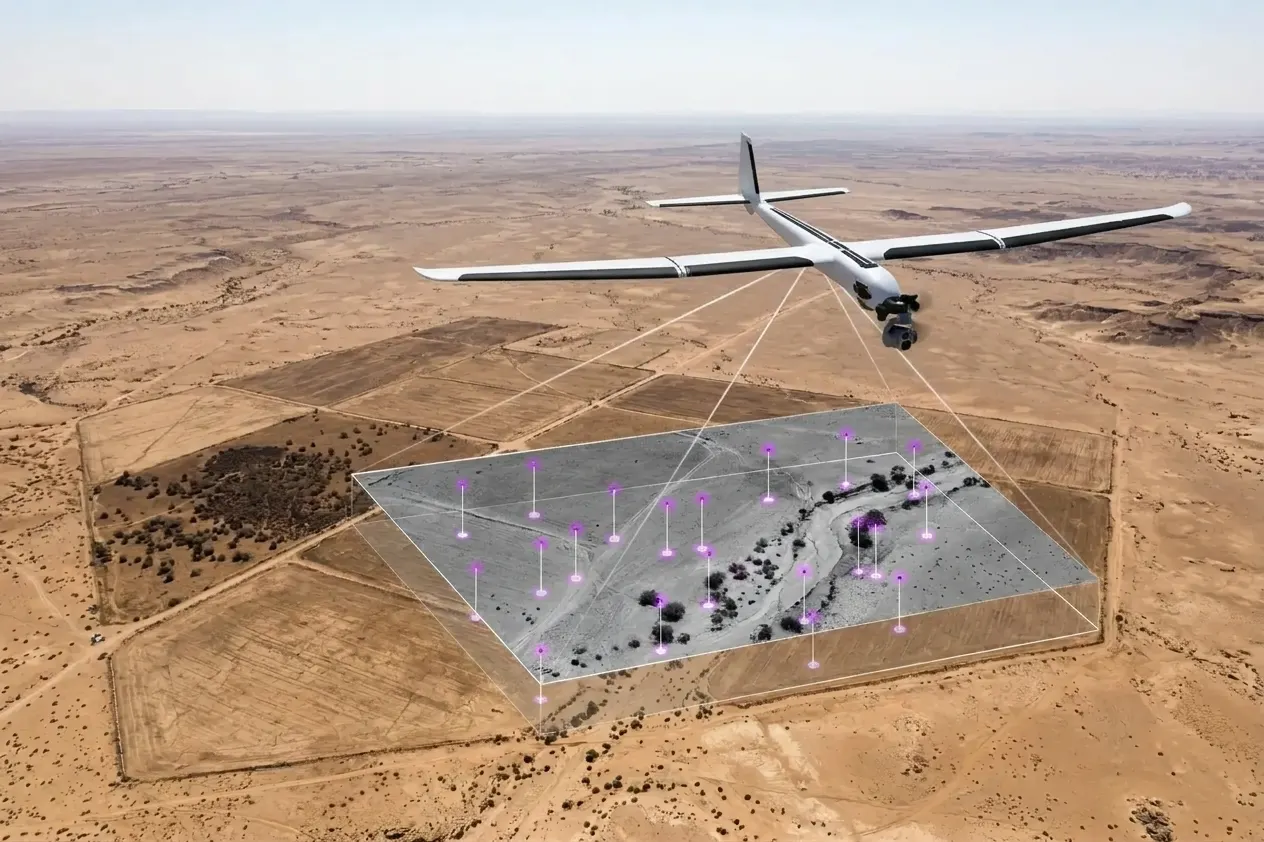
The idea of a drone or missile working out where it is by looking at the ground is older than GPS. Tomahawk cruise missiles were doing it in the 1980s. Today it is one of the most popular topics in military engineering. At military academies and engineering universities, cadets regularly build visual positioning systems (VPS) as their final-year projects, and many of them work in a demo.
At the same time, GPS denial has become routine wherever there is fighting. So if the idea is decades old, a student can build a working version, and the need has never been greater, why isn't visual positioning standard on every military drone?
The short answer is that a demo over a university campus on a clear day is the easy part. Everything that comes after it is hard.
GPS denial is now routine
Satellite navigation signals are weak by the time they reach the ground, which makes them easy to drown out (jamming) or imitate (spoofing). Both are now routine.
- On the battlefield. Aerospace America's year in review says the war in Ukraine turned GPS denial "from a theoretical risk to a tactical norm", with drones and munitions misnavigating every day. According to testimony to the US Congress, the GPS-guided Excalibur artillery shell hit about 70% of its targets when it was first used in Ukraine and about 6% six weeks later, once Russian jamming had adapted.
- In the air. By August 2024 around 1,500 airline flights a day were being spoofed, according to industry data cited by the Irish Aviation Authority. IATA's figures show GPS signal losses roughly doubling between 2021 and 2025, from 28 to 57 per 1,000 flights. In September 2026 two airliners lost satellite navigation over Sweden and landed using conventional radio aids.
- At sea. In the first weeks of the Iran war in March 2026, monitoring centres recorded more than 600 GNSS disruption events in a single day around the Strait of Hormuz. Ships appeared on tracking maps sitting at airports, on land, or sailing in circles.
Spoofing is the more dangerous of the two. A jammed receiver knows it has lost its signal. A spoofed receiver confidently reports the wrong position. The only way to catch that is to compare it with something independent, and a camera looking at the ground is one of the few independent sources a small drone can carry.
How visual positioning systems work
There are two broad approaches, and most real systems use both.
Visual odometry tracks how features move from one camera frame to the next and estimates how the aircraft has moved. It needs no map, but it only measures relative movement, so its errors add up over time.
Map matching compares what the camera sees with stored, georeferenced imagery or elevation data and works out an absolute position. That position is passed to the autopilot as if it were a GPS fix, and the inertial sensors carry the aircraft between fixes.
Tomahawk used the second approach. Its DSMAC system (Digital Scene Matching Area Correlator) compared a downward camera image with stored scenes near the target and gave the missile its most precise positions, around 10 metres. It worked because every mission had reference imagery prepared for it in advance. That requirement turns out to be the centre of the whole problem.
It isn't only for GPS denial
Visual positioning is also useful when GPS works perfectly. A drone's position is only one input. To work out where its camera is looking, and therefore the coordinates of anything it sees, it also needs its heading, attitude and height, and those sensors are often worse than the GPS.
On small and medium UAVs, the compass is frequently offset by a few degrees, thrown off by motors, wiring and nearby metal or simply poorly calibrated. Barometric altimeters drift with the weather and can be tens of metres off. These errors don't stop the aircraft flying, but they ruin anything built on its video. Footage draped on the map is shifted and rotated, and the coordinates read from it, whether for a target, a vehicle or a damaged bridge, are wrong by tens or hundreds of metres.
Matching the camera image against reference imagery and elevation data fixes this. Once the system knows exactly where a few points in the image are on the ground, it can work out the real heading, attitude and height and correct the inertial and compass readings, and the whole frame then lines up with the map. We use similar techniques in Elite SPRINT to keep live drone video accurately placed on 3D terrain, even when the aircraft's own sensors are off.
Who is using it now
Visual positioning is being fielded, mostly in Ukraine and mostly as a backup to GPS:
- Ukrainian company Twist Robotics has built OSCAR, a module that matches camera images to mapped landmarks and feeds the result to the autopilot. The company claims 20 metre accuracy and more than 500,000 km of testing.
- US–Ukrainian startup Vermeer raised a $10 million Series A in October 2025 for its multi-camera VPS, which is already in use with Ukraine's armed forces.
- Israel's ASIO sells camera-only navigation for tactical drones and reports strong sales to the Israel Defense Forces.
- Vantor, the satellite imagery company formerly known as Maxar, sells Raptor, software that matches a drone's camera images to its own 3D terrain data. Vantor reports under 10 metres of accuracy, at night and at low altitude, using the drone's existing cameras. It has partnered with BAE Systems and Niantic Spatial, and in October 2026 completed flight tests with Sightline Intelligence combining visual positioning with target recognition.
- On the other side, a Shahed-type drone recovered by Ukraine in June 2025 carried an Nvidia Jetson Orin AI computer and an infrared camera for visual terminal guidance.
Meanwhile, the largest government programs are betting on other methods too. In a Defense Innovation Unit test, Honeywell's magnetic navigation system guided an Embraer 170 for more than four hours without GPS. Ukraine has also gone around the radio problem entirely: it received 374,000 fiber-optic drones in 2025, which can't be jammed because they are controlled through a cable.
So visual positioning is real, but it is one option among several, and it is still far from the default. These are the reasons.
Why isn't visual positioning on every military drone?
Not every landscape has something to see
Map matching depends on distinctive features: road junctions, buildings, field boundaries, rivers. Over desert, open plains, snowfields, steppe or open water there may be nothing distinctive to match. Repetitive ground is almost as bad. Rows of crops, forest canopy and dunes look the same from one kilometre to the next, so the system can find a confident match in the wrong place. Many of the places where militaries operate are exactly this kind of terrain.
Light and weather add to it. Cameras lose contrast at night, under low cloud and in smoke, haze and fog. Thermal cameras help at night, but a thermal image looks very different from the daylight satellite imagery most maps are built from, and matching one to the other is still an active research problem.
Drift gets worse the longer you go
Between fixes, the aircraft relies on visual odometry and inertial sensors, and both drift. A few metres of error after a minute can become hundreds of metres after a long stretch over featureless ground. The longer the system goes without a good match, the worse its position estimate becomes, and the larger the area it has to search to find the next match. A poor estimate makes the next match slower and more likely to be wrong, so the problem compounds.
The camera has to know which way it is pointing
To place what the camera sees on a map, the system has to project the image onto the ground. That projection depends on the aircraft's attitude, the gimbal angles and the height above the ground, and small errors in any of them turn into large errors on the ground.
The geometry is unforgiving. A camera 500 metres up, looking 60 degrees away from straight down, sees a point about 870 metres ahead. If the pitch reading is off by one degree, that point moves by about 36 metres. Cheap gimbals have encoder errors, mounting play and vibration, and their small IMUs drift with temperature. Those errors are larger than one degree more often than designers would like.
Steep, oblique views make everything worse, but they are often what a drone has. A loitering munition or FPV drone usually looks forward and down, not straight down the way a mapping satellite does. Correcting for that slant (orthorectification) is what makes the image comparable with a map, and it only works if the angles are right.
It needs good elevation data, and that is expensive
Orthorectification also needs to know the height of the ground. Get the height wrong and the image is shifted sideways, by roughly the height error multiplied by the tangent of the viewing angle. At 45 degrees off vertical, a 10 metre height error moves the image about 10 metres. At 60 degrees it moves it about 17.
This is why a serious VPS needs a surface model (DSM) that includes buildings and trees, not just bare terrain. The free global elevation datasets have 30 metre cells and leave out most buildings and treelines, which is exactly where the errors appear.
High-resolution elevation data costs far more than high-resolution imagery. 50 cm satellite imagery can be bought from archive for roughly $8 to $18 per square kilometre. An indicative price for a 0.5 metre DSM is about €55 per square kilometre, several times more, and fresh airborne lidar costs more again. Elevation data is also much harder to find for many parts of the world, and in a war zone it goes out of date as fast as the imagery: a destroyed building changes the surface model as well as the picture.
The imagery has its own age problem. Satellite reference maps are often months or years older than the flight. Seasons, crops, snow, flooding, new construction and battle damage all change what the ground looks like. Research on season-tolerant matching is improving this, but there is still no standard for how fresh a reference map needs to be.
You can't carry the whole map
A drone can only match against maps it carries, because downloading them in flight means relying on the same radio links that are being jammed.
Take an area of 100 by 100 kilometres at 50 cm resolution. That is 40 billion pixels, about 120 GB of uncompressed colour imagery. A surface model at the same resolution adds even more. Compression and lower resolutions bring this down, but at the cost of the detail the matching depends on. A long-range drone flying a 1,000 km route needs maps for a corridor along the whole route, plus margin for detours. Cheap drones have small, slow storage.
So every mission needs its maps chosen, cut and loaded ahead of time. That is a planning and data-logistics task, and it grows with the number of drones. Tomahawk could afford a dedicated reference-imagery process for each mission. A force launching thousands of drones a day can't, unless the process is automated.
Reading the map fast takes compute
Having the map on board isn't enough. The system has to search it quickly enough to keep up with an aircraft moving at 100 to 200 km/h. That means indexing the imagery and elevation data in advance so the right tiles can be found and compared within milliseconds, then running the matching itself on every fix.
Indexing a large area properly, so that both the imagery and the surface model can be searched quickly, needs more processing power and memory than most small drones have.
AI-based visual positioning has problems of its own
Deep learning has made matching much more robust to season, lighting and viewpoint than older hand-written feature detectors. It has also added a new set of problems.
Benchmark results don't transfer to the field
Most open-source models for matching drone images to satellite maps are trained and tested on a handful of academic datasets. They report state-of-the-art accuracy on those datasets and much less outside them. The most widely used, University-1652, uses synthetic drone views rendered from 3D models of university buildings. When one recent study trained a model on one dataset and tested it on another, accuracy for finding the right satellite tile from a drone image fell to about 43%.
Even a correct result in these benchmarks usually means picking the right tile out of a set of candidates. It doesn't mean producing a position accurate to a few metres, at an unfamiliar altitude, at night, over a region the model has never seen. Most of these models were built for controlled trials, and that is where they perform well.
Making a model production-ready means rebuilding it
To work in the field, a model has to be retrained on imagery from the regions, seasons, altitudes, cameras and sensors it will actually use. In our experience, retraining is usually not enough. Many research architectures are designed for data-centre GPUs and for accuracy on a leaderboard, not for speed, memory or reliability. Making one barely functional on a drone often means changing its architecture or rebuilding it, and that is a long way from downloading a model and fine-tuning it.
Onboard compute is limited
A drone can't carry a data-centre GPU. A popular module like Nvidia's Jetson Orin NX runs in power modes of about 10 to 25 watts, so models have to be shrunk, simplified or quantized until they fit. Heat is a real constraint too. In a small sealed enclosure, sustained inference can push the chip into thermal throttling, which shows up as dropped frames, just when the system needs to keep up. Fans, heatsinks, power supplies and extra battery all add weight and cost to an aircraft that may be designed to be lost.
Supply is a problem as well. The AI boom has made memory, and the GPUs that depend on it, scarce and expensive. In April 2026 Nvidia began phasing out several Jetson modules because of memory prices and tight supply. A drone design that depends on a specific module can be held up for months by its lead times.
Data is the moat
Algorithms get published and hardware can be bought. Good data is much harder to get, and in visual positioning it is what separates a system that works from one that doesn't.
If you are building an AI-based system, you need a very large amount of flight imagery, and each image has to come with an accurate record of where the aircraft really was and which way the camera was pointing. That data has to cover the terrain types, seasons, times of day, altitudes, viewing angles and sensors the system will meet in service, including thermal at night. A model only learns the conditions it has seen.
Even without AI, you still need that data to test the system. A matching algorithm can't be trusted until it has been checked against flights where the true position is known, over desert, forest, farmland and towns, in summer and winter, by day and by night. Collecting that means flying the same areas again and again, with precise reference positioning on board, and then processing and labelling everything. It is slow and expensive, and every new region or sensor means doing it again.
This is a big part of why Ukrainian companies have moved fast. Twist Robotics' 500,000 km of testing is the kind of dataset that a lab can't easily reproduce, and it keeps growing with every flight.
The same logic explains Maxar's change of direction. When the company split in October 2025, its imagery business renamed itself Vantor and said it wanted to be seen as a spatial intelligence company rather than a satellite imagery provider. Its visual positioning product, Raptor, is built on the global 3D terrain data it already owned. For an imagery company, visual positioning is a way to sell the map.
Digital twins can fill some of the gaps
Synthetic data can't replace real flights, but it can reduce how many are needed. A detailed 3D model of an area, a digital twin, can be used to render views from any altitude, angle, time of day or season, including ones that would be dangerous or impossible to fly. Every rendered image comes with a perfect record of where the camera was.
Our Elite Mapper supports this in two ways. Its photorealistic Gaussian splats can render training and test views that look very close to real camera footage, much closer than the synthetic views in benchmarks like University-1652. Its monoplotting support works the other way round: it takes a single real image, places it against the terrain model and recovers real-world coordinates for what it shows. That lets real drone footage be labelled with ground positions without surveying every frame by hand.
The usual caution applies. A model trained only on synthetic data inherits the gap between the rendering and reality, which is exactly the problem with today's benchmarks. Synthetic data works best for widening coverage and for testing rare conditions, with real flights still used to check the results.
The hard part is the data
Building a visual positioning system that works in a demo is a student project. Building one that works over a featureless plain at night, on a cheap gimbal, with a year-old map, on a 15-watt computer, on thousands of drones at once, is a different job.
Most of what stands in the way is not the camera or the matching algorithm. It is the data and everything around it: current imagery, accurate elevation models, correct orthorectification of oblique views, maps cut and indexed for each mission, and enough real and synthetic flight data to train and test against real conditions instead of benchmarks.
That is also why the systems being fielded today combine several methods: inertial sensors, visual positioning, magnetic navigation, satellite signals when they can be trusted. Each one covers gaps in the others, and vision is particularly useful for catching spoofing.
These are problems we work on every day. Elite SPRINT orthorectifies live drone video onto 3D terrain in real time, which depends on the same gimbal angles, surface models and imagery as visual positioning. Elite Mapper manages imagery and elevation data at petabyte scale, and its digital twins can generate and label the data these systems need. In our view, the militaries that get visual positioning working at scale will be the ones that treat it as a mapping and data problem first, and an aircraft problem second.
References
- Global conflicts expose GNSS vulnerabilities, inspire innovation, Aerospace America
- Russian jamming leaves some high-tech U.S. weapons ineffective in Ukraine, The Washington Post (via Anchorage Daily News)
- Aeronautical Services Advisory Memorandum on GNSS interference, Irish Aviation Authority
- Why planes are getting 'lost' due to GPS spoofing and jamming, RTÉ
- GPS jamming and spoofing disrupts two airline flights over Sweden, Avi-Go
- Electronic fog of war: GPS spoofing distorts ship traffic near Hormuz, gCaptain
- Tomahawk Cruise Missile Navigation, Johns Hopkins APL Technical Digest
- Ukrainian company Twist Robotics develops visual navigation system for drones, Ukrainska Pravda
- Ukraine gives drones vision-based navigation to push past heavy jamming, The Defense Post
- Vermeer secures $10 million Series A to advance GPS-free drone navigation, DroneLife
- Drone navigation firms seek new ways past warzone jamming, Bloomberg
- What's in a name: Goodbye Maxar, hello Vantor and Lanteris, Breaking Defense
- Raptor: don't depend on GPS for mission success, Vantor
- Maxar launches Raptor, software for GPS resilience in autonomous systems, Vantor
- Niantic Spatial and Vantor partner on air-to-ground positioning in GPS-denied areas, Vantor
- Autonomous systems achieve high-precision navigation and targeting in GPS-denied flight tests, Unmanned Systems Technology
- Components of upgraded Shahed-136 with camera and AI, Defence Intelligence of Ukraine
- DIU and Honeywell flight test MagNav system, DefenseScoop
- Ukraine has delivered 92% of last year's fiber-optic drone total in under four months, Euromaidan Press
- Real-time elevation and orientation-aware visual localization for GNSS-denied drone navigation, Drones (MDPI)
- A visual navigation system for UAV under diverse illumination conditions, Applied Artificial Intelligence
- General place recognition survey: towards real-world autonomy, arXiv
- Season-invariant GNSS-denied visual localization for UAVs, arXiv
- How much does satellite imagery cost in 2026?, Geopera
- Satellite imagery pricing, SkyWatch
- Elevation data pricing guide, ESA Global Development Assistance knowledge hub
- University-1652: a multi-view multi-source benchmark for drone-based geo-localization, arXiv
- Enhancing cross-view geo-localization generalization, arXiv
- NVIDIA Jetson Orin NX power tuning, RidgeRun
- NVIDIA phases out several Jetson modules due to high LPDDR4 RAM prices, CNX Software